
Built in 1866, Enoggera Reservoir is the oldest reservoir in Brisbane. It was the third large dam built in Australia in the 1800s and was one of the dams constructed to store water for Brisbane’s growing population from 1864 to 1916.

In 1976, the concrete spillway was added and the embankment raised for flood mitigation. Enoggera has a two level spillway. The lower level has two rectangular culverts that tunnel under the concrete crest. When the full supply level is reached, water flows through the culverts and out of the dam. The upper spillway has a concrete ogee crest.During major floods, water will also flow over the upper spillway.
Although Enoggera Reservoir is not currently used for water supply in South East Queensland, it could supply drinking water during drought and is also a unique and much loved recreation destination in the heart of Brisbane.
It is an un-gated dam, meaning that when it reaches 100 per cent capacity, water flows over the spillway and safely out of the dam. If you would like to be notified when Enoggera Dam begins to spill, please sign up to our free dam release notification service.
Enoggera Reservoir celebrated its 150th year anniversary in 2016. Download a copy of A celebration of Enoggera Reservoir
For residents living downstream of Enoggera Dam, click here to read more about how the dam has been designed and constructed, what Seqwater does to manage the dam and how the dam performed during the heavy rainfall associated with ex-Tropical Cyclone Debbie in March 2017.
Recreation

Mountain biking is permitted at Enoggera Reservoir, with trails linking to the national park tracks. There are also walking tracks that link to the national park in the surrounding forest.
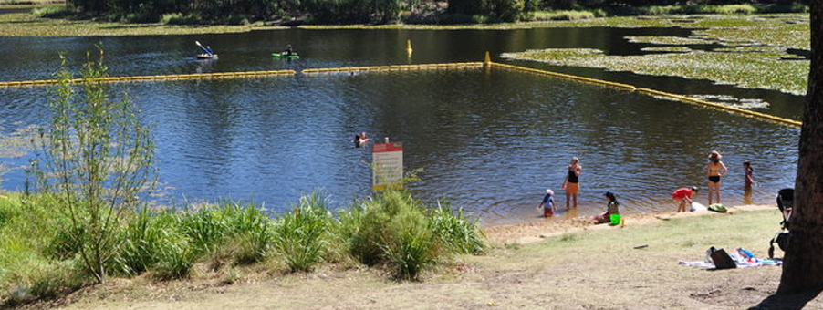
As a result of our Recreation Review, a designated swimming area and paddle craft launch point are available at the reservoir. The new facilities can be accessed via the Queensland Parks and Wildlife Service Walkabout Creek Visitor Centre at 60 Mount Nebo Road, The Gap.
Read the Enoggera Reservoir Recreation Guide* for more information.
Key facts
| Name: | Enoggera Dam |
|---|---|
| Watercourse: | Enoggera Creek |
| Location: | The Gap |
| Catchment area: | 33.0km 2 |
| Length of dam wall: | 380.0m |
| Lake surface area: | 75.0ha |
| Year completed: | 1866. Upgraded in 1976. |
| Type of construction: | Concrete & rock-face earth & rockfill dam |
| Full supply waterline: | 74.3mAHD (above sea level) |
| Fully supply capacity: | 4567ML |
| Current capacity: | 4,577 (100.2% full) at 16-01-2018 2:56am |
| Spillway level: | 80.4mAHD |
House prices are on the rise. Find out the value of your property now.
Get a free online property report from Hicks Real Estate. It takes seconds.
Hicks Real Estate Team
Hicks Real Estate is a Brisbane based, full-service real estate agency supporting buyers and sell as well as renters and property investors. With almost 20 years experience in the local market, we are the real estate experts you can rely upon.